
Updated on August 2, 2026 @ 3PM
|


Now Updated for 2026!
Current Weather Links:


2025-2026 Seasonal Snowfall Total
Fulton: 204.0" Syracuse: 143.1" Oswego: 127.6"
through April 7, 2026
Fulton: 204.0" Syracuse: 143.1" Oswego: 127.6"
through April 7, 2026
Additional Links:
SUNY Oswego Webcam
New York State Golden Snowball Award Contest
2007 Oswego County Lake Effect Storm Video
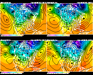
Weather Models and Links
8 Day Forecast:
Monday |
Tuesday |
Wednesday |
Thursday |
Friday |
Saturday |
Sunday |
Monday |
 |
 |
 |
|
 |
|
|
|
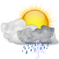
High: 76 |
High: 80 |
High: 85 |
High: 85 |
High: 84 |
High: 80 |
High: 84 |
High: 86 |
Low: 58 |
Low: 64 |
Low: 69 |
Low: 69 |
Low: 69 |
Low: 66 |
Low: 67 |
Low: 70 |
|
Forecast Discussion: Low pressure will continue to give us on and off showers Sunday night. The rain will be pulling out just after sunrise Monday morning. Clouds will eventually give way to some sun in the afternoon. A few showers still possible into early afternoon over northern NY. A cool and more comfortable night Monday night. A nice warm and sunny day on Tuesday with high pressure over our area. We are warmer on Wednesday with a mix of sun and clouds. The humidity returns on Thursday with partly cloudy skies and a chance of some afternoon showers. Warm and humid on Friday with sun and clouds. Some scattered showers or storms are possible especially during the afternoon. There is still a chance of some showers next Saturday. But best chances of rain are toward the southern tier of NY. Otherwise partly cloudy, warm and humid. Partly cloudy skies and still humid next Sunday. Warm and humid with a mix of sun and clouds for next Monday. |
Meteorologist
Anthony Corsoniti

Bachelor's of Science in Meteorology
from SUNY Oswego
Anthony Corsoniti
Bachelor's of Science in Meteorology
from SUNY Oswego